Overview
The park covers 307 square kilometres, spanning the border of both Phitsanulok and Loei Provinces, and is best known for its history, having supported a communist base from 1968-1972, as well as its geology. The geography is mostly mountainous with the highest peak at 1,820 m. Habitats are a mixture of deciduous, dry dipterocarp, dry evergreen, and hill evergreen forests. Unfortunately much of the evergreen forest was destroyed during the communist and government fighting, so the remaining areas are somewhat restricted. Much of the interesting geology, and some excellent views can be found along the two kilometre loop trail just southeast of the HQ. From a birding perspective, the most interesting species is Nepal House Martin, with Phu Hin Rong Kla being the only regular site in Thailand for this species, and which is assumed to breed, but not proven. The upland forest holds a selection of the usual northern montane species. This park is not well visited nor watched by birders. Jerdon’s Bush Chat has been found in the area, and Dusky Crag Martin is quite common. Information on this page verified/accurate as of 2 Dec 2021.
|
|
AccessThe park is situated about 130 kilometres east of Phitsanulok. From Phitsanulok take Highway 12 east toward Lom Sak and after 68 kilometres turn north, onto Highway 2013, to Nakhon Thai which is reached after a further 30 kilometres. The park is sign-posted along this road. At Nakhon Thai take Highway 2331 toward Phu Hin Rong Kla and Lom Sak. The park entrance is reached 31 kilometres along Highway 2331, although several junctions along the way make it appear as the road is not direct. As Highway 2331 runs directly through the park an entrance fee is payable irrespective of whether you are actually visiting the park or simply driving to Lom Sak. The park HQ, accommodation and visitor centre are found about five kilometres from the entrance checkpoint. Although less direct, the park can be entered from the east side, at the Taberg checkpoint, via Lom Sak which is about 40 kilometres away. Accommodation and FacilitiesThe park has a number of fairly priced bungalows for between two and 12 people. The accommodation appears to be in good condition and well-maintained - a rarity in Thai parks. There is also a campsite, although own tents are required. Two restaurants found at the HQ are open from 07:00 till about 20:00. A small shop has basic provisions. A good option is to stay in Lom Sak to the east and travel the one hour to the eastern side of the park. Unfortunately, in 2015, advertising of the area on Thai TV produced a flood of dry season visitors with a large number of tacky tourist accommodations springing up on the eastern flank of the mountain below the Taberg checkpoint. It seems highly unlikely any of these can have long term viability, and solely consistute a blot on the landscape. The park management also decided to cash in on this new found fame and now charge 500 Baht for foreign visitors. |
Birding
Highway 2331
Much birding can simply be done along Highway 2331, running the 37 kilometres between the checkpoints, through the middle of the park. A variety of forest types can be explored along this road. Mid week the road does not seem busy with traffic, but no doubt over a weekend it would be better to explore a few of the trails. A good selection of forest species can be expected including Red-billed Scimitar Babbler, Silver-eared Mesia, Davison's Leaf Warbler and Great Barbet. It would be possible to spend the whole day birding along this lengthy route.
Loop Trail
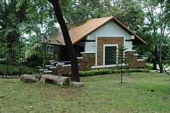
A two kilometre loop trail passing through open, and some closed forest can be found two kilometres southeast of the HQ. This is the most popular trail in the park as it passes a number of communist artefacts, and has some impressive views and geological formations, such as the nodule field along its southern edge, where Dusky Crag Martin can be found. It would be wise to avoid this trail during busy times at the park.
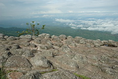
Taberg Checkpoint and Scenic View
More impressive views can be found just outside the eastern edge of the park at the Taberg checkpoint. Habitat disappears immediately once outside the park with cabbage fields taking over. From the checkpoint follow Highway 2331 down the mountain a kilometre or so stopping to scan the skies for Nepal House Martin, and any rank vegetation for Jerdon’s Bush Chat. About one kilometre below the checkpoint, park the vehicle, and climb the low ridge to the east of the road and scan for both species in the valley beyond.
Checklist
Checklist of species.
Gallery
Additional images from Phu Hin Rong Kla available in the Thailand Travel gallery.
Sunrise and Sunset
Detailed sunrise and sunset times.