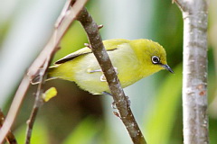
Overview
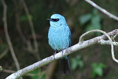
Mae Wong National Park spanning nearly 900 square kilometres within Nakhon Sawan and Kampaeng Phet provinces, was gazetted in 1987. The habitat is a mixture of forest types, much of it heavily altered by earlier agriculture and logging, as well as secondary growth and grassland. These forests form part of the western forest complex, with a number of resident species associated with areas of Burma farther west. From a birding perspective the main targets are Burmese Yuhina and Rufous-necked Hornbill, since Mae Wong is the most accessible area of Thailand where these species are regularly recorded; though unfortunately neither are easily found. The yuhina is most likely commonest on Mokoju Peak, at 1,964 metres the highest peak in the park, but access requires a three day trek each way. Note that this section of the park, as well as Mae Kra Sa Waterfall and Mae Rewa Waterfall are closed to visitors from 1 July to 30 September. Other restricted range species of interest include Khalij Pheasant, Spot-necked Babbler, Olive Bulbul, Long-tailed Sibia, Rufous-browed Flycatcher, Brown-crowned Scimitar Babbler and Crested Kingfisher. Visitors to the higher elevations within the park will encounter a potentially serious problem with small biting flies, prevalent at all times of the year, and mainly in open areas such as around the campsite. Shoes, long trousers, long-sleeved shirts, a hat and insect repellent are essential. Those who react strongly to insect bites should bring antihistamine medication. Information on this page verified/accurate as of 4 Feb 2023.
|
Access
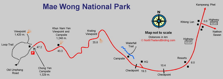
The park lies 100 or so kilometres northwest of Nakhon Sawan. Coming from Bangkok, head north on Highway 1 and turn west onto Highway 1242 between Nakhon Sawan and Kampaeng Phet - the park being sign posted. Highway 1242 then joins Highway 1072 about ten kilometres from Khlong Lan. If coming from the north, from Chiang Mai or Tak, turn onto Highway 1117, sign posted Khlong Lan, a few kilometres south of Kampaeng Phet. Driving time from Chiang Mai is about five hours, and around four hours from Bangkok. Once at Khlong Lan head south along Highway 1117 to the park entrance, checkpoints and HQ.
Accommodation and Facilities
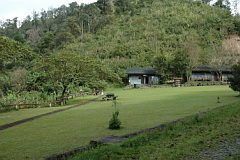
Within the park the usual national park bungalows and campsites can be found. These are centred in two areas; the first near the HQ, and the second at Chong Yen at the top where the old track to Umphang starts. If staying at the lower HQ campsite, next to the river, a small restaurant is available at the HQ, but only between 08:00 - 16:00. Those staying on the mountain at Chong Yen need to take all food and camping equipment if camping. The campsite at Chong Yen has a beautiful location, but is very small, so can be packed at popular weekends. The campsite slightly downhill at Khun Nam Yen is a better bet, as it is more spacious, with larger washroom facilities. A few small, basic rooms are available for rent at Chong Yen as well.
The best accommodation facilities are found just outside the park along highway 1117, but staying here will require extra driving morning and evening in order to reach the upper levels of the mountain. Three resorts can be found between the park entrance and Khlong Lan town. The town itself has a selection of small stores, with a good restaurant on the southwest corner of the junction of highways 1117 and 1072. Three fuel stations are available at Khlong Lan, with fuel available from about 07:00 - 18:00.
A second checkpoint is located just beyond the HQ, at the start of the Chong Yen mountain road. Access beyond this checkpoint is restricted to daylight hours from 06:00-18:00, although how this is handled by staff at the checkpoint varies. Speaking politely to the staff might allow subsequent early entry on subsequent days. However this checkpoint can be locked and unattended. Note also that it closes at dark, although staff seem to remain if informed of a return just after dark. To pass this checkpoint a daily vehicle pass sometimes needs to be collected from the park HQ, which unfortunately is usually open only after 08:00.
Birding
Lower Section - Entrance Road, Headquarters and HQ Campsite
Once inside the entrance checkpoint the few fields quickly change to lowland forest with extensive bamboo and some riparian forest along the river on the northern side of the road. Access off the this road is limited until the park HQ is reached after nine kilometres. Walking around the HQ, with its open areas and larger trees, is likely to produce the usual collection of sunbirds, flowerpeckers and bulbuls. This is also a good area for Red-billed Blue Magpie.
|
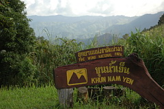
A kilometre or two farther past the HQ is one of the lower campsites, immediately adjacent to the river. Crested Kingfisher occurs along this river, but it could be a long wait before one flies past this particular spot. The river has many tributaries, some of which are crossed on the road up to Chong Yen, so a stop and scan anywhere has a chance of producing this species. The Waterfall Trail, recently in poor condition, can be found across the river from the campsite, and a Nature Trail, mainly through bamboo, starts at a bridge across the river just before the HQ. Middle Section - Road to Krating Viewpoint Once past the checkpoint at the HQ the road winds up, initially through fairly dense lowland forest, through a succession of cleared forest, secondary growth, and rank grasslands. Lower stretches hold Brown-cheeked Fulvetta, Abbott's Babbler and Ashy Minivet in winter. The Krating Viewpoint, 16.5 km after the checkpoint has excellent views across the valleys below and could potentially have Rufous-necked Hornbill in the appropriate season. Large Scimitar Babbler, a bird awkward to find in Thailand, is relatively common in scrub around the viewpoint. As more of the speciality species occur higher on the mountain, this middle stretch of road is largely overlooked, but no doubt would be worthy of exploration, time permitting. This whole stretch of road was badly damaged by landslides in the 2022 monsoon, with extensive repair work still continuing into 2023. Upper Section - Khun Nam Yen Viewpoint to Chong Yen Eight kilometres beyond the Krating Viewpoint the Khun Nam Yen Viewpoint and campsite are reached. From here good views across a number of forested slopes can be had, and it makes an excellent vantage point to watch migration in spring and autumn, with regular groups of Chinese Goshawk and Crested Honey Buzzard. The surrounding rank grass holds Siberian Rubythroat, Lanceolated Warbler and Baikal Bush Warbler in winter. Other birds include Greater Flameback, Oriental Hobby, Mountain Imperial Pigeon and Brown-backed Needletail. |
The remaining four kilometres, from Khun Nam Yen to the upper campsite at Chong Yen, contain the most accessible evergreen forest, and it's worth walking this whole section several times if possible. Common highland birds include Mountain Imperial Pigeon, Great Barbet, Golden-throated Barbet, Blue-throated Barbet, Bay Woodpecker, Grey-chinned Minivet, Grey Treepie, Flavescent Bulbul, Davison's Leaf Warbler, Yunnan Fulvetta and Striated Yuhina.
|
Less frequently found along this stretch include Rufous-browed Flycatcher, Spot-necked Babbler, Olive Bulbul, Rufous-throated Partridge, Bar-backed Partridge, Black-winged Cuckooshrike, Chestnut-crowned Warbler, Pin-tailed Green Pigeon, Blue Pitta and Rusty-naped Pitta. Of the specialities Brown-crowned Scimitar Babbler is mostly found in bushes near the Chong Yen campsite, together with Collared Babbler and Red-billed Scimitar Babbler. Biting flies permitting, it is worth spending time around the campsite as Burmese Yuhina and Rufous-necked Hornbill are most often reported from there. |
From here a trail goes steeply uphill to a viewpoint offering much improved views than from the campsite, and would be a better place to scan for hornbills. Stripe-breasted Woodpecker and Spot-necked Babbler occur along this trail. The old track to Umphang has long since overgrown and is now effectively a forest trail that offers good opportunities for birding. How far one can progress along it is likely to vary with time of year and usage. A short way along it a loop trail branches off right, very steeply down into the valley below, to reemerge at the bottom of the Viewpoint Trail.
Checklist
Checklist of species.
Gallery
Additional images from Mae Wong available in the Thailand Travel gallery.
Sunrise and Sunset
Detailed sunrise and sunset times.