Overview
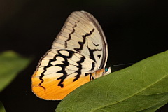
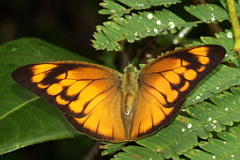
Khao Soi Dao Wildlife Sanctuary is a wilderness area, located 70 kilometres north of Chanthaburi. Its ornithological interest lies in it being the western most extent of the Cardamom Mountains stretching into Cambodia that are an important endemic bird area, holding a number of distinct species and forms, many of which in Thailand can only be found at this locality. However, birding at Khao Soi Dao is very tough, with the specialities only readily found at altitude, that basically requires undertaking a major hike and camping. Two peaks can be contemplated - Khao Soi Dao North (Neua in Thai) and Khao Soi Dao South (Dtai in Thai). At 1,630 metres the southern peak is the higher. Any trek here is best attempted in the drier period from November to March as a trip outside this period risks being washed out in this high rainfall area. In addition to birds, many interesting butterflies can be found at Khao Soi Dao. Information on this page verified/accurate as of 11 Dec 2016.
|
AccessFrom Chanthaburi take Highway 317 north toward Sa Kaew and Soi Dao. About 20 kilometres north of Pong Nam Ron the sanctuary and Khao Soi Dao waterfall are well signposted. If coming from the north or west from Bangkok, Chonburi or Prachinburi, a variety of routes are possible; either via Sa Kaew and then onto Highway 317 southward, or through Tha Takiap on Highway 3259 joining Highway 317 north of Soi Dao. |
Accommodation and Facilities
Being a wildlife sanctuary, not a national park, public accommodation is not available within the park other than the campsite. A number of bungalows are available for official visitors and researchers, which could possibly be available by contacting the main offices in Bangkok in advance. Fortunately several resorts are found within striking distance outside the sanctuary, either in Soi Dao town or farther back along the main highway toward Pong Nam Ron.
The park HQ has a small restaurant, and just outside the checkpoint are a number of stalls selling cooked food, fruits and snacks, although these can only be relied to be open during daylight hours. Back at the junction to the Khao Soi Dao turnoff on Highway 317 a convenience store and petrol station can be found. The town of Pong Nam Ron has a number of stores as well as Internet access.
|
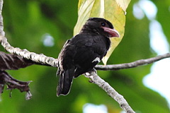
BirdingA fair list of specialities include Blue-rumped Pitta, Black-browed Fulvetta, Indochinese Green Magpie and Chestnut-headed Partridge. Although the first two of these have been recorded at the lower elevations around the park HQ, at about 300 metres, and along the waterfall trail, all are extremely rare here and realistically to find them it's necessary to trek higher, that in turn presents some logistical difficulties. Birding at Khao Soi Dao requires time and patience, as for long periods the forest can seem devoid of birds. HQ, Campsite Area, and road to the Waterfall Open areas and forest edge around the HQ and campsite area are good places to start birding. Fruiting trees attract a variety of barbets including Green-eared Barbet, as well as sunbirds, flowerpeckers and green pigeons. Watch open areas for needletails, as all three species are regularly seen. The short walk along the road toward the barrier to the waterfall is a great place to find Dusky Broadbill. The density of Asian Barred Owlet here seems to be the highest in Thailand. After the barrier, the two kilometre road to the start of the Waterfall Trail, offers the easiest birding access to forest, and is recommended. The road can get busy with visitors to the waterfall and the barrier is only officially open from 06:00 to 15:30, after whch it is considered dangerous to be in the area due to roaming elephants. The river behind the campsite can be interesting, and it is possible to walk along its edge. Old Loop Trail Lack of maintenance and dilapidated signs make finding and following this trail now impossible. The viewpoint platform, if it can be found, is now overgrown with vegetation blocking the view, although a platform still exists. If attempting this trail, take a GPS. The easiest place to start is at the barrier to the waterfall where an obvious narrow track leads to an old toilet block. A wider forest track is found behind the toilet block which should be followed right and uphill. |
New Nature Trail
A new Nature Trail, opened in 2015, is currently easy to follow though at the end of 2015 already had a few tree falls. It is well signposted and starts next to the restaurant just after the entry checkpoint. It passes through a mixture of forest types and looks interesting. Beware of numerous leeches on this trail in the wet season.
Waterfall Trail and Khao Soi Dao North
The first kilometre or so of this trail, up to waterfall level 5, offers access to good forest and understorey on an easy to follow, well used and flatish trail. Blue-rumped Pitta has been seen along here and Coral-billed Ground Cuckoo occurs. After level 5 the trail is much harder to follow and gets steeper, and requires crossing to the other side of the river, around level 11, which can be treacherous in the wet season. Thereafter the trail becomes very steep with roped sections, until it eventually arrives at level 16, at about 600 metres altitude, where it peters out. Views across the forest from the upper levels are worth the climb and should be a good place to scan for needletails. After level 5 it is preferable to take a ranger from the sanctuary HQ. Supposedly it is possible to continue from level 16 up to the summit of Khao Soi Dao North, but it would seem necessary to cut a trail and camping would be necessary. To arrange a ranger/guide, and potentially porters, and camp here it is necessary to ask permission at the HQ, though this has not been possible since November 2013.
Captive Breeding Centre
Just outside Pong Nam Rong, sign posted on the left as travelling north, 1.8 kilometres north of main junction in town, is the sanctuary captive breeding centre, where a large number of cages hold a variety of species including Silver Pheasant and Green Peafowl. As the area backs onto forest some interesting birds should occur, but it would be necessary to find trails into the forest to really work the area, which seem lacking. By following a rough track to the left of the entrance gate it is possible to ascend to 490 metres before the trail disappears into thick forest, from where it would be necessary to use a GPS to continue.
Khao Soi Dao South
Hiking up Khao Soi Dao South and camping is the best way to ensure access to the speciality species of the area. This requires a permit, guide and probably porters, and the steep hike up is usually two days to the summit. As arrangements for doing this, and the logistical situation can change, the best approach is to ask initially at the park HQ, where staff can advise the latest situation and contacts. However, in November 2014, the sanctuary management were not permitting more than one night on the mountain, effectively closing the upper areas, above 900 metres to visitors.
Checklist
Checklist of species.
Gallery
Additional images from Khao Soi Dao available in the Thailand Travel gallery.
Sunrise and Sunset
Detailed sunrise and sunset times.